Showing posts with label arch bridge. Show all posts

Wednesday, March 19, 2014

Sagamore Bridge, Bourne Bridge and Cape Cod Canal Railroad Bridge, Cape Cod, MA

Sagamore Bridge, Bourne, MA
It's been a year since my last post... this is a gap too long. I've still been taking bridge pics, just -- not posting, for some reason. I dunno. New bridges mean driving further and further... still worth doing, but now they require a bit of planning to get to.

Spring has finally come to New England after a horribly long winter. I've been wanting to hunt the bridges that cross the Cape Cod Canal for a long time, but it's always been either too cold, or too filled with tourists. These bridges are a huge bottleneck for people traveling to and from the cape. The roads from Bourne to Provincetown are narrow and slow. There might be just a couple of weekends left before the antique shops re-open and the cars start to pile up. This was my chance to get these bridges before it was too late for another year.

Buzzards Bay Railroad Bridge, and OMG MY CAR!!!
The Cape Cod Canal is a seven mile canal formed by connecting and widening two rivers that allow shipping to and from further down the East coast to get to Boston-area ports without having to round the cape. The Wikipedia mentions that George Washington once surveyed a potential path for the canal... building on work the Pilgrims had begun a hundred years earlier. This canal, though, is only about a hundred years old.

The Sagamore Bridge on the north end of the canal, and the Bourne Bridge near the southern end, are both steel arch bridges with suspended roadways. They carry a substantial number of cars each day, but during summer, the lines of cars waiting to cross can reach miles long. This is why many residents opt to use the Cape Cod Canal Tunnel to skip the crowds.

Bourne Bridge
It was pretty cloudy when I got to the cape, so I apologize for the dullness of the Bourne and railroad bridge pictures. When I got to the Sagamore Bridge on the way home from Provincetown, the day was much nicer. I probably should have gone back to Buzzards Bay and re-taken those bridge shots, but -- it had been a long day.

Long, paved trails stretch along both sides of the Cape Cod Canal, and both sides were crowded with people out for a walk, a bike ride, or roller blading. I really should have brought my bike. Behind the Bourne Bridge in the picture just above are a few wind turbines. The constant winds through the hills surrounding the canal turn the turbines and help power the Massachusetts Military Reservation. Cape Cod will also soon host the Cape Wind project, an offshore wind farm that has just last week cleared its last legal hurdle. Detractors claim the sight of turbines turning lazily on the horizon will kill the tourist trade (and unwary seabirds), but.... I have loved wind farms since I first saw the ones in Pacheco Pass and Altamont Pass back in California.

Here's a better picture of the Buzzards Bay Railroad Bridge, AKA the Cape Cod Canal Railroad Bridge, without my car in it.
Cape Cod Canal Railroad Bridge
This bridge, the southernmost bridge over the Cape Cod Canal, is a lift bridge that services the tourist trade -- a local area tourist train (the Cape Cod Central Railroad) and an express train from the Boston area (the CapeFLYER). Since I went out of season, neither train was running and the bridge stayed up the entire time I was in the area. There's enough traffic in the canal to keep boat watchers happy; while I was photographing the Sagamore Bridge, a tug pushing a barge, followed by another tug, zoomed by.
I'm disappointed in myself for taking so long to visit these wonderful bridges. Best thing about them is -- there's an entire cape of wonderful things just pass them.

Cape Cod Highlands Lighthouse, Truro

Edward Penniman House, Eastham

Pilgrim Monument, Provincetown

Town Cove, Eastham
It's not easy to miss these bridges if you're going to Cape Cod; in fact, they're impossible to avoid. All pictures were taken with a Canon G 1X point and shoot camera. I brought my Canon DSL, but I just ended up using the small camera because the pictures were coming out just as nicely.
Happy bridge hunting!

Saturday, July 28, 2012

Ashton Viaduct, Cumberland-Lincoln, RI

The Ashton Viaduct crossing the Blackstone River
Usually a bridge like this has a lot of history behind it, but I can't even get a definite idea of its name. Some places call it the Ashton Bridge, some the Ashton Viaduct. I imagine it was associated with the nearby (like, if I turn to my right 90 degrees, it's right there) Ashton Village, which was once a thriving mill, so it must be at least a hundred years old, but... no information on how old it is.

I was biking on the Blackstone Valley Bikeway which stretches from Worcester, Massachusetts through to Cumberland, Rhode Island. I was just wanting to see how far I could get, maybe to where I grew up near Uxbridge, Mass., before we moved to New Hampshire. The Blackstone Valley was home.

Yeah, I knew the viaduct would be along the way, but still. I didn't come just for the bridge. Honestly.

The Ashton Mill
Told ya the mill was close.

Viaduct & bike bridge
The Ashton Viaduct is a five span open spandrel arch bridge crossing the Blackstone River, a river once called the most polluted river in the country with respect to toxic sediments, being used as it was as the industrial toilet for mills and factories from Worcester to Woonsocket. It is today still filled with pollutants. In that it shares a fate with the Housatonic River here in Connecticut -- enjoy at your own risk.

Neither river is likely to ever fully recover.

Not the Albion Bridge
Further along the bikeway, I found a pony truss bridge crossing the river. It looked in great condition, better than I'd ever seen one from the age of iron bridges. It didn't look to be one of the Berlin Iron Bridge Company's bridges -- most of theirs are lenticular.

Boston Bridge Works Builders
These bridges were built by the Boston Bridge Works... at least originally.

Turns out that Rhode Island  replaced the bridge, then bolted on parts of the old bridge so it would keep some of its old character. According to the contractor, Gordon R. Archibald Inc Civil Engineering,
To maintain the historic value of this river crossing, Gordon R. Archibald, Inc. developed the innovative concept of 'aesthetic rehabilitation.' Under this concept, the trusses were refurbished and placed astride a new, two-dimensional steel grid superstructure. The steel grid carries all of the new superstructure and vehicular loadings, leaving the trusses to carry only the weight of and loadings on the sidewalks. In this way, the reconstructed bridge can carry contemporary traffic loadings, while its 19th-century visual quality is preserved for future generations.
So I'm not sure how I feel about that. I guess it's good that they didn't just replace it with a slab of steel and concrete. They replaced it with a slab of steel and concrete and then put it in a dress.


Thursday, July 5, 2012

Meadow Road Bridge/Pequabuck Bridge, Farmington, CT

Meadow Road Bridge
A few weeks ago, I did a mondo post on every bridge on the national historic register in Hartford County. I got most of them. Except the Pequabuck Bridge in Farmington. I thought the Pequabuck Bridge was the one that the Pequabuck River ran beneath. That was wrong.

Still not the Pequabuck Bridge. Is it?
Or, well, maybe not. Because even the Pequabuck Bridge isn't called that any more; it's the Meadow Road Bridge, because the river was diverted at some point to the new place, and now the only really significant thing about the bridge is the path over, part of the East Coast Greenway, a network of paths and trails stretching down the entire east coast.

From the 1984 application for the national historic register
The Pequabuck Bridge is an arched, brownstone span that was built between 1832 and 1833. It's a rubble stone bridge; the outside of the arch is made of shaped and fitted sandstone, but most of the rest of the stones are roughly shaped or not shaped at all. The bridge was built with a wooden structure forming the arch, the outsides of the arch were fitted on that, including the keystones to hold them in place, and then they filled up the frame with stones and lime-based mortar until they filled it to the top. They removed the wooden frame in the arch, and had themselves a bridge.


The wooden bridges I photograph are usually fairly new because wood bridges just don't last -- even if done in the style of the bridge they replaced, they are not the same bridge. This is the real thing. Stonemasons built this bridge a hundred and thirty years ago, and it still stands today. The only change -- the mortar is now concrete instead of lime. This bridge could easily last another hundred and eighty years, especially now that no river runs through it.


Back in the 19th century, this bridge took people from the crowded town of Farmington into what was called the Great Plain, a large plateau of fields, meadows and swamps. This bridge was, then, a vital part of the local economy and needed to be strong and last. This bridge replaced at least one wooden bridge, and you can easily imagine the frustration the townsfolk felt at having to keep repairing and replacing the wooden bridge, causing them to build a bridge that would last.


Part of the Great Plain area was incorporated as the town of Plainville, so that's how that got its name.

I'm just going to copy text wholesale from the historical register application, because the history of the area and its bridges is fascinating.


In  the  second  half of  the  18th  century  the  quest  for  land  to  cultivate impelled the  sons of Farmington residents  to range  farther and  farther  from the  central  settlement.  Led  by members  of  the  well-to-do Cowles  family, Farmington  people  established  farms  in  the  Great  Plain,  the  area  that  was incorporated  as  the  town of  Plainville  in  1869.  After  the  Revolutionary War,  agricultural-based  commerce  underwent  tremendous  expansion,  as Farmington  farmers  sold  their  surplus  output  to  local  merchants  who assembled  shipments  of  grain and  cattle  to  sell  in  the  nation's  growing cities  or  to  export  to  the  West  Indies.  These  two  trends  of  geographic expansion  and  commercial  growth put  pressure  on  the  transportation  routes over  which  farmers  carried their  goods  to  the  merchants  in  the  center. 
Farmers west of  town,  from the  Great  Plain and  its  northern meadows,  had to cross  the  Pequabuck River,  which  lay  between  their  farms  and  the  town  cen­ter,  so  this  crossing came  in  for  close  attention.  In  1801,  the  town meeting appropriated $200  to  improve  the  wooden bridge  then  in  place.  Then in  1819  the  town  rebuilt  it  entirely,  using timber.
Farmington merchants played an  important  role  in  the  promotion and  financing of  the  Farmington Canal.  The  canal  increased  the  town's prosperity,  making it  a  market  center  for  the  region  including not  only western Farmington  but also  Burlington and Canton.  The  surge  in  road  traffic  that  resulted again brought  the  conditon of bridges to  the  top of  the  town's agenda.  In  1830 a committee  of  the  selectmen plus  two western  farmers,  Richard  Cowles  and Joshua  Youngs,  was  appointed to  study  the  town's  bridges.  Two were  found inadequate:  Pequabuck Bridge  (i.e.,  Meadow Road  Bridge)  and  Perry's Bridge in  the  northern part of  town.  The  relatively greater  importance  of  the Pequabuck crossing  is  apparent  in  the  committee's  recommendation to  rebuild it  in  stone,  while wood was  specified  for  the  new Perry's  Bridge. 
The  recommendations  took  full  account  of  physical coordination  with  the canal,  which Meadow Road crossed about  450  feet  east of  the  Pequabuck River. The  committee made  the  requirements  that  the  new  stone  bridge be  the  same height  as  the  one  over  the  canal,  and  that  an  embankment be  built  between the  two bridges  so  that  travel  would proceed at  a  constant grade.  Without the  embankment,  wagons would have  had  to  climb and descend  two  rises within several  hundred  feet.  The  resolution that  approved the  plan was  contingent on  the  canal  company's  agreeing  to  "raise  and extend  the  Canal  bridge embankment between  the  canal  bridge  and  river  bridge,  in  such manner as  that the  one  may be  adapted  to  the  other;  arid  provided that  the  canal  company will  permit  the  town  to  take  gravel  from the  Company's  ground  for  the purpose of extending the  embankment westwardly  from the  river  bridge." 
The  relative prosperity of  Farmington,  and  the  provision of materials by  the canal  company,  enabled construction of  the  stone  bridge.  Connecticut  towns rarely  undertook  such  ambitious bridge-building  projects  in  the  early  19th century;  the  great  majority  of  town  bridges  in  the  state  were  of  wood.  
There  was  not  even a  mason  in  Farmington who  could perform  the  work,  so Horace  Cowles  took on  the  task of  finding  a  qualified contractor.  His  four finalists  came  from the  towns  of  Windham,  Woodbridge,  Watertown and Haddam. (The  contract  for  the  bridge's  construction has  not  survived,  so  it  is  not possible  to  determine  which  of  the  four  actually  performed  the  work.) Farmington was  not  extravagant with  its  public  expenditures,  despite  opting for  the  more  expensive  stone  construction.  Economical  construction  was assured  by  limiting  the  cutting  and  fitting  of  stones  to  only  the  areas where  it  was  absolutely necessary,  the  outside  edges  of  the  arch.  Even with the  savings  from this  technique,  the  bridge  cost  $1,081,  nearly  twice  as much  as  the  $546  it  took  to  rebuild Perry's  Bridge  in  timber.  The  limited use  of  cut  stone  makes  Meadow  Road  Bridge  highly  distinctive.  In comparison,  Hartford's  Main  Street  Bridge,  another  arched brownstone  span from the  early  1830s,  has  cut-and-fitted masonry  for  the  entire  underside  of the  arch,  the  spandrels  and  the  parapets.
The  idiosyncratic  mix of  finished and unfinished stone  identifies  Meadow Road  Bridge as  the product of a  specific  time  and  place.  Farmington  had more wealth than most  inland Connecticut  communities,  permitting the  use  of the  more  expensive  stone  construction.  But  its  people  still  retained  the basic conservative  impulse  of outlying Connecticut  towns,  and  they would not countenance  the  fullest  application of  expensive masons'  labor.  Thus  Meadow Road  Bridge  illuminates  the  concerns of  a  community as  its  economy  evolved from one  of  subsistence and  local  commerce  to  one of market  growth based  on regional  and extra-regional  trade.  The  bridge  also makes clear  the  impact of  the  Farmington Canal.  Not  only did  the  canal  contribute  significantly  to the  growth of  the market economy,  but  it  altered the  physical makeup of  the town  and  forced  the  townspeople  to  adapt  their  road  system  to  the  new conditions.
Meadow  Road  Bridge  belongs  to  an  extremely  small  group  of  early  19th-century,  masonry  town bridges.  Ante-bellum stone  bridges were  built  by the  Housatonic  Railroad and by  factory owners,  but publicly  funded  stone bridges  were  not  common.  Meadow Road Bridge  and  Hartford's  Main  Street Bridge  are  the  only examples of  their  size  known  to  survive  in  the  state.


Saturday, June 16, 2012

Historic Bridges of Hartford County

Melrose Road Bridge, East Windsor
There's eight bridges in Hartford County, Connecticut that are listed in the National Register of Historic Bridges. I had a yen to go visit them all in one day. I got to seven; that's when the muffler fell off my car, and I came home. The last is the Bulkeley Bridge, which I have written about before, so no big loss. Here are the other seven bridges, in the order in which I visited them.

The black and white photographs are from the accompanying documentation to the historic registry applications, and were in most cases taken at the time of the application to illustrate what it is that made this bridge historically significant. I didn't take them.

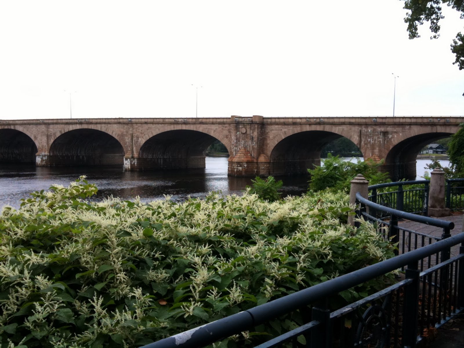
First bridge up is the Melrose Road Bridge in East Windsor. This pony truss bridge sits at the very end of Melrose Road, hidden by shrubbery, without a road bed. A walking trail along the Scantic River goes by the bridge. This bridge was built by the famous Berlin Iron Bridge Company, but they didn't install it. The city just wanted them to build the parts and drop it off, so that's what they did.

Bridge overgrown on both ends now.
The application for registered historic status has a fascinating look at the Melrose Road Bridge and the famous Berlin Iron Bridge Company. Note the lens-shaped curved structure of the truss; that was patented by the Berlin Bridge Company and this signature feature is one of the reasons this bridge has such great historical value.

I can just see a large, long wagon being pulled by a team of eight horses carrying a bridge all the way from Berlin in 1888. Though apparently they shipped the bridges in a partially assembled state via train. Well, I'm sure huge horse-drawn wagons were used at some point.

If I ever find myself shifted in time back to the late 19th century, I'm going to try and get a job at the Berlin Iron Bridge Company. Maybe I could do accounting for them, or something.

On the far bank of the river is a railing. Once, this bridge went somewhere; there was something on the other side; homes, villages, people. Now there's just forest. Someday soon this bridge will collapse into the river.

Bridge No. 455, Suffield
I thought I hadn't noticed ever driving over this bridge, and I may not have. I've biked over it, though -- twice -- during my single day photographing every bridge in Connecticut that crosses the Connecticut River. I remember at the time wondering if this bridge was worth photographing.

It's an open spandrel bridge, hidden by trees from every angle I could get to. I did see a state facilities road leading down and perhaps that could have given a better view of the bridge; I'll have to return with bicycle and see as there's no legal place to park nearby. Or just wait for winter and get it when the trees have no leaves.

This photographer wisely waited for winter to photograph the bridge
Bridge no. 455 is one of only six reinforced concrete, open spandrel arch bridges left in Connecticut. It replaced an earlier iron truss bridge and leveraged its unique design to rise high above the ravine in which Stony Brook runs. The earlier bridge sat much lower and had steep grades on either side. It is a marvel of 1920's engineering.

More detail about this bridge is available in its registration forms.

Farmington River Railroad Bridge, Windsor
For a small river, the Farmington River is oversupplied with beautiful bridges. We'll get to the Town Bridge soon, and I spotted a truss bridge crossing the river in Unionville, and another outside Simsbury that didn't make the register of historic bridges.

This railroad bridge carries the Penn Central line between Hartford and Springfield, Massachusetts. If the train had chosen the time I was there to make the crossing, I couldn't have been happier, but we were trainless the entire time. Built in 1867, the bridge has seen continual service and aside from periodic maintenance, looks identical to the time when it was built 145 years ago.

Farmington River Railroad Bridge in 1972, with train
This bridge, like the Main Street Bridge below, is made from Connecticut's signature reddish sandstone. More details can be found, as with the others, in its registration forms.

Stone Bridge on Main Street, Hartford
The looming glass building behind and above the old Main Street bridge is the Hartford Public Library. It's quite a contrast to the stonework of the bridge that once crossed the Park River. Now the river is filled in and is called the Whitehead Highway, but the bridge is still there. I first wrote about the Main Street Bridge in January.

This bridge once rose a full thirty feet above the river and was almost a full half circle arch, but since that's been covered, it's only twelve feet above the road at its highest, and most of the bridge is below the ground. Incidentally, the Park/Hog/Little River still flows through enormous underground tunnels that you can explore (or rather, could explore, but it seems to have been closed off. Or has it?

Stone Bridge and the Park River
So daring was this bridge's construction that it cost almost double what was budgeted and was (wrongly) considered so unstable that farmers arriving for the market that was held on the shores of the Park River would leave their horses on one side of the bridge and carry their produce over the bridge themselves rather than risk everything crashing, with the bridge, into the river below.

More info about the bridge in its registration forms.

Not the Pequabuck River Bridge, Farmington
This is not the Pequabuck River Bridge. It is a bridge over the Pequabuck River, but it is not the bridge that is on the register of historic places. THAT bridge is a little further down the road. I JUST NOW noticed that. I feel like such a moron.

I guess I'll write more about that bridge once I actually photograph it.

This is a nice bridge, though.

Town Bridge, Canton
I first photographed this bridge back in March, just after the last, light, snowfall of winter. I was a little disappointed with how the picture came out. It's a nice bridge, just off River Road/Route 179 in Canton. People were swimming, fishing, just having fun in the shallow waters of the Farmington River. The group traveling upriver in their rented kayaks made this picture, and for that I thank them.

Town Bridge from the portal
The Town Bridge was another example of the work of the Berlin Iron Bridge Company. This bridge uses the Parker truss design -- an improvement over the more common Pratt truss. The tops of Parker truss bridges curve, where the Pratt truss bridges are straight. We have both sorts in Hartford County. The curved top gives more strength to the center of the bridge, allowing it to bear greater weight. However, construction of this sort of bridge is more expensive than a standard Pratt truss, and was only used in longer bridges that needed the extra strength.

Note the iron work ornamentation on the bridge, typical of Victorian-era engineering.

I was pleased to read in the registration documents that after the Berlin Iron Bridge Company was bought out by J. P. Morgan's American Bridge Company, the former employees started the Berlin Steel Company and that company still exists today. One of the corporations that made Connecticut famous and changed the face of the Northeast in the 19th century, still doing business.

Old Drake Hill Flower Bridge, Simsbury
Our last bridge for today is the Old Drake Hill Flower Bridge in Simsbury.

That's what the sign called it, anyway. The flower bridge. It does have lots of flowers on it. There was some sort of function going on on the other side of the bridge so I didn't get the chance to walk over it. Walking over it is all you can do; it's closed for all but foot traffic.

Auto traffic has its own bridge. This bridge, the old one, is at the end of a bike trail that extends for miles. Simsbury is trying very hard to become the best city for bicycling in the state of Connecticut. Wide bike paths and plenty of places to pull off the road and look at the sights definitely puts this on the list of places I'd like to visit on two wheels.

A road once ran through it
This, like Canton's Town Bridge and another Simsbury bridge that I have not yet photographed, is a Parker truss bridge -- curved top -- and are the only surviving examples of this sort of bridge in Connecticut. All three are said by the registration documents to have been designed and built by New Haven's J. E. Buddington. Oddly, the documents for the Town Bridge didn't mention Buddington's involvement with the design, but it seems likely the Berlin Iron Bridge Company served as the fabricator for Buddington's variant of the Parker truss.

The Simsbury selectmen really, really wanted the previous wooden bridge over the Farmington River to be replaced by an iron bridge, but they couldn't pay for it. First, they allotted some money to strength the abutments and approaches to the old bridge, and when that work was done, they turned to actually erecting a new bridge.

Raising taxes to pay for bridge construction wasn't going to fly with the citizenry, and nobody wanted to secure a commercial credit note for the bridge (since if the city defaulted, who needs a bridge?). The city eventually floated five series of $2,000 bonds to pay for the bridge without raising taxes. They later did the same to pay for the other Parker truss in Simsbury.

Wednesday, May 23, 2012

Pelham Bay/Shore Road Bridge, Bronx, NY

Pelham Bay Bridge
It's still catch-up week here at Life, On a Bridged. This weekend is going to be a post about three beautiful bridges in the Portsmouth, NH area, and next week is going to be Covered Bridge Week. (Preview: we cover the most haunted bridge in the Berkshires!)

But for now, we're in the Bronx, at the Pelham Bay/Shore Road Bridge.

Usually when I visit the Bronx, I go by train. It's convenient, comfortable and even fun. Once in the city, the subway and buses bring me anywhere I need to go. This is how things were for years, until I got a car. While following the Merritt Parkway into New York, I came for the first time to NYC in a car. And that made all the difference. Unlike traveling in a train, in a car I could get lost. And while lost, I could find things.

I'd hoped to get a NYC bridge while I was in the area before heading back home to Connecticut (and I did, the Bronx-Whitestone Bridge). On the way to that bridge, I passed over this bridge. I immediately turned around, parked at the Bronx Equestrian Center, and looked for someplace with a good view of the bridge.

I didn't have to go far; there is a trail off of City Island Road (which has some pretty cool bike paths) which goes right up to the mouth of the Hutchinson River, over which the bridge runs.

The bridge is one of the busiest drawbridges in the city, second only to the Hamilton Avenue Bridge in Brooklyn. (Reading that report, btw, I bet I could spend a year, easy, just photographing New York City's historic bridges). It was completed in 1909, replacing a wooden bridge that crossed the river nearby, and celebrated its centennial a couple years back.

It's not a long bridge, but you can walk over it and enjoy both halves of the Pelham Bay Park (and landfill!). Say what you like about NYC, they have amazing parks. This trip I visited the Pelham Bay Park and the Ferry Point Park and was impressed by them both.

Sunday, May 20, 2012

Sawyer Bridge AKA "Bridge to Nowhere", Hillsborough, NH

Sawyer Bridge
The stone arch bridge in Hillsborough, NH was the subject of a blistering stump speech by presidential candidate Mitt Romney, who asked how $180,000 of stimulus money was spent on a bridge that connects to no road and carries no traffic.

Bridge, in the news, in driving range -- I headed right up to get a look for myself at this "bridge to nowhere".

It's a nice enough bridge. Recently maintained, with a railing around it so you can walk around on top of it without falling into the Contoocook River, which it crosses. The Hillsborough folks say they were thinking of building a park around it, but it's certainly not in the center of anywhere.


Signs on either side of it tell the history of the bridge:

Stone Arch Bridges

Beginning in the 1830s, a few arched granite
highway bridges were built in southern New
Hampshire under the supervision of engineers
from major manufacturing centers. By the 1850s,
rural stonemasons had mastered the art of
building such bridges without mortar. Hiram
Monroe (1799-1871), active in town affairs,
persuaded Hillsborough to build a dozen. Five
survive, and a sixth is covered by Franklin
Pierce Lake. Among the local builders were
Reuben E. Loveren (1817-1883), and brothers
Calvin A. Gould (1826-1877) and James H. Gould
(1828-1890). All three worked on this, the
double-arched Sawyer Bridge, in 1866.

I'm wondering where the other four surviving stone bridges are...  It's interesting that the sign mentions that stonemasons had mastered the art of building stone bridges without mortar, while the Sawyer Bridge clearly uses a ton of mortar. Perhaps that was put in during the renovation.

According to Gilman Shattuck, historic bridges like the Sawyer Bridge are important reminders of our past.

Mr. Shattuck, a former member of the New Hampshire House of Representatives and a Democrat, also happened to be a contributor to a book of historical images of city. He wrote the chapter on bridges. Sites like the Sawyer Bridge, he said, are important history landmarks that help out with the New Hampshire tourism industry.
“We’re talking sofa money, sofa change money,” Mr. Shattuck said of the stimulus dollars funneled to the bridge. According to the Associated Press, the total amount of stimulus funding used to repair the bridge was $150,000.

Parking is pretty much anywhere. There are parking lots surrounding it. Not sure it's worth a special trip; I fit in five covered bridges and a trip to the New Hampshire seacoast along the way and that made it worthwhile to me.

Friday, March 2, 2012

Bulkeley Bridge, East Hartford-Hartford, CT

Bulkeley Bridge from Great River Park, East Hartford
I have to accept that I never will take the "perfect" picture of Bulkeley Bridge. This bridge is made from thousands of shaped stones, and I believe is the longest stone arch bridge in the world. It carries I-84 over the Connecticut River between Hartford and East Hartford. There's a pedestrian walkway along the south side of the bridge, just recently repaired. The bridge condition was getting pretty dire.


It's not easy to get a good sense for how massive this bridge is from pictures alone. You have to get close enough to see all the individual carved stones that make up the bridge and just try to imagine the work that must have gone into each one. They fit together perfectly. I took the top picture last weekend with my DSLR camera; I took the one just above this paragraph a couple years ago with a Samsung point and shoot.


This one I took last summer, after Hurricane Irene decimated the forests that line the Connecticut River and the debris was left to drift downstream, to fetch up against the Bulkeley. You can see just how high the river had risen after the storm.


This is the very first picture I took of the bridge. I'd been driving on top of it for a couple of years, but had never stopped to see what the bridge actually looked like. The stone of the bridge changes character with the light.

The Bulkeley Bridge is the center of river recreation in both cities; the parks on both sides are filled with sculptures, paths, boat landings and such. An "after Independence Day" celebration takes place on the Hartford side each year; sometimes they put colored lights under the arches and light them at night (haven't managed to catch that in advance, yet).


A view of the north side of the bridge, from Riverside Park. Done with really faky HDR before I knew what I was doing. The first picture in this posting is also HDR, but in the year or so since I took this picture, I've figured out about balancing the exposure levels between the composite shots and stuff. Doesn't mean the picture is any good, but at least everything is the correct hue and luminance. Some people have figured out how to do crazy HDR that looks totally unearthly. I don't necessarily WANT to do that -- those photographs tend to be so noisy I can barely figure out what the picture is of -- but I'd like to have that tool in my toolbox to make my pictures look more abstract.

Anyway. Plenty of parking on both sides of the bridge, though on the Hartford side you're more likely to be made to pay. I don't remember if you have to pay to park in the boathouse parking lot.

If you ever come to Hartford, take time out to visit the Bulkeley Bridge. Come when there's something going on and make a day of it. When Hartford puts its mind to it, it's a really nice city.

Saturday, February 25, 2012

Memorial Bridge, Springfield-West Springfield, MA

Springfield

A couple months ago, I photographed some bridges up in Holyoke. On the way back, I thought I'd get some pictures of the South End/Buxton Bridge, a bridge I'd never photographed before. I was snapping shots along the way and as I got to the far end of the bridge, saw that I could get a good bit of the Memorial Bridge in the shot. I fell in love with that sky and promised myself I'd go back after I got my new camera.

The shot above was taken with my old camera, the Canon G12.


Today was supposed to be clear, but instead was cloudy and windy. I hoped for as good a picture as the top one. The sky grew more overcast as I drove north (Springfield isn't that far away, but apparently far enough). When I got to Springfield, there were even flurries in the air. The puffy clouds were gone.

Still, I'd driven all that way. I parked in the Pynchon Point parking lot in Agawam, took some pics of the Buxton Bridge from the ground, climbed to bridge level and walked to where I'd taken the first picture. It took a few minutes to get the tripod and camera set up -- and then the clouds to the south broke, illuminating Springfield and the Memorial Bridge.

I got the shot.

This is the point where the Westfield River flows into the Connecticut River. I wrote about the Great River Bridges a couple of days ago -- they cross the Westfield River in Westfield.

Friday, February 10, 2012

Edgewood Ave Bridge, New Haven, CT


The weekend for my Connecticut River Cruise / Bald Eagle (photo) shoot / East Haddam Bridge Re-visit finally arrives and the climate remembers it's supposed to be winter. They've cancelled the morning cruises Saturday and Sunday, and the later cruises on those days are "watch this space!". I won't know if Sunday is a go until Sunday morning.

Anyway. Last weekend's third stop after Bridgeport and Stratford was friendly old New Haven, just three quarters of an hour south. New Haven provides a calm harbor for shipping where the Quinnipiac River flows into Long Island Sound. New Haven is also home to Yale University, which today's bridge is kinda near. Well, honestly, anywhere in New Haven is kinda close to Yale. Its tendrils reach throughout the city.


The Edgewood Bridge crosses the West River in the center of Edgewood Park (just head down Yale Boulevard; you'll find it; it's near the Yale Bowl). It's made of steel-reinforced concrete. Special care was taken with the molded balustrades and other ornamentation to make the Edgewood Bridge truly spectacular. With the ornate railings above, and the road/jogging path running through the arches below, this is a bridge truly meant to be seen and appreciated.


You can park along the street. Access to the path and river is via staircases at all four corners of the bridge. Edgewood Park is a really, really nice place, and I can just imagine how wonderful it will look in season. Come for the park, definitely, but go by the bridge while you're there.

Monday, February 6, 2012

The Bridges of Bridgeport: Congress Street Bridge, et al


With a city named "Bridgeport", how could a bridge hunter go wrong? It was the Congress Street Bridge that made the list of historical bridges -- you can see it blurrily in the background there -- but the city is known for its large number of bridges.

Well, the Congress Street Bridge is closed. The movable bit -- the bascule -- is removed, and the bridge is all blocked off.


Here's a picture of the other side of the Congress Street Bridge. It's a nice enough bridge. It was frozen in the upright position, and I was hoping to get a shot of that. But they were gone, and what's left is nothing worth a trip.


Turning to the other direction is a nice lift bridge. It carries the Amtrak tracks over the Pequonnock River.


There's another lift bridge around the bend in the river that carries pedestrian and auto traffic across the river, and finally, the biggest bridge of all...


The I-95 bridge over the river. It continues south along the coast to New York City, and east toward the mouths of the Housatonic, Quinnipiac, Connecticut and Mystic rivers -- each of which bear prettier bridges.