Showing posts with label hartford. Show all posts

Sunday, March 25, 2012

Charter Oak Bridge, Hartford-East Hartford, CT

Charter Oak Bridge
It doesn't carry as much traffic as the Bulkeley Bridge, and it isn't the city centerpiece that Founders Bridge is, but the Charter Oak Bridge, the third (and newest) of Hartford's bridges across the Connecticut, has its own reasons to shine.

The Charter Oak that gave its name to the Hartford neighborhood where this bridge lands is a tree of legend in Connecticut. In 1662, the story goes, King James II decided that the colonies had had quite enough of this independence thing and appointed a governor, Edmund Andros, over the newly created Dominion of New England. When he arrived in Hartford to revoke Connecticut's charter, he was shown it, and then the candles blew out. When relit, the charter was gone -- hidden, it was said, in a huge oak tree, the Charter Oak, in south Hartford. In 1689, Andros was deposed and the Dominion of New England dissolved.

The original Charter Oak was split by lightning 150 years later, but its descendants live on, and the wood of the original tree was made into a chair which stands now in the State House.

Connecticut has always prided itself on its independence -- it was the first state to ratify the Constitution. The Charter Oak is Connecticut's symbol.

Charter Oak Bridge from the tour ship landing
The East Hartford side of the bridge stands in a small park which is (unfortunately) rather marshy. The Hartford side ends in Charter Oak Landing, the main dock for boats both personal and commercial in Hartford.  The Lady Katherine river tours leave from here. (The boat used to leave from Riverside Park near Founders Bridge, dunno why they moved down here). The public landing is on the south end of the park; the north end gives magnificent views of of the Colt Park section of Hartford (marked by the colorful dome on the old Colt Firearms factory) and of the Hartford skyline.

Charter Oak Landing
This picture may have been processed a little bit. I was having some fun with the new version of Picasa. You can see the Colt factory dome on the left of the photo.

Obligatory car shot
I don't honestly know how to get to the park in East Hartford. I've only been there on my bike, and I got there from the bridge itself, which features a wide, separated bike path on the north side. Charter Oak Bridge carries routes 5 and 15 over the river; following those signs will get you there. Or just click on the location information beneath this post and use Google Maps to get you there.

I've gotten to the end of this post without talking much about the bridge itself. You can see from the pictures that it's not all that special, a very modern girder bridge built with steel and concrete, similar to the East Windsor river crossing. It was built between 1988 and 1991 to replace an earlier bridge at the same point. Anyone going from I-84W to I-91S will cross the bridge and will never see the beautiful parks beneath it.

Friday, March 2, 2012

Bulkeley Bridge, East Hartford-Hartford, CT

Bulkeley Bridge from Great River Park, East Hartford
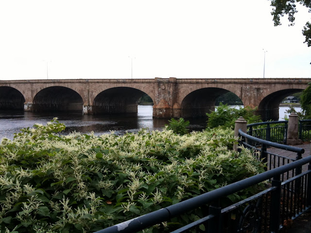
I have to accept that I never will take the "perfect" picture of Bulkeley Bridge. This bridge is made from thousands of shaped stones, and I believe is the longest stone arch bridge in the world. It carries I-84 over the Connecticut River between Hartford and East Hartford. There's a pedestrian walkway along the south side of the bridge, just recently repaired. The bridge condition was getting pretty dire.


It's not easy to get a good sense for how massive this bridge is from pictures alone. You have to get close enough to see all the individual carved stones that make up the bridge and just try to imagine the work that must have gone into each one. They fit together perfectly. I took the top picture last weekend with my DSLR camera; I took the one just above this paragraph a couple years ago with a Samsung point and shoot.


This one I took last summer, after Hurricane Irene decimated the forests that line the Connecticut River and the debris was left to drift downstream, to fetch up against the Bulkeley. You can see just how high the river had risen after the storm.


This is the very first picture I took of the bridge. I'd been driving on top of it for a couple of years, but had never stopped to see what the bridge actually looked like. The stone of the bridge changes character with the light.

The Bulkeley Bridge is the center of river recreation in both cities; the parks on both sides are filled with sculptures, paths, boat landings and such. An "after Independence Day" celebration takes place on the Hartford side each year; sometimes they put colored lights under the arches and light them at night (haven't managed to catch that in advance, yet).


A view of the north side of the bridge, from Riverside Park. Done with really faky HDR before I knew what I was doing. The first picture in this posting is also HDR, but in the year or so since I took this picture, I've figured out about balancing the exposure levels between the composite shots and stuff. Doesn't mean the picture is any good, but at least everything is the correct hue and luminance. Some people have figured out how to do crazy HDR that looks totally unearthly. I don't necessarily WANT to do that -- those photographs tend to be so noisy I can barely figure out what the picture is of -- but I'd like to have that tool in my toolbox to make my pictures look more abstract.

Anyway. Plenty of parking on both sides of the bridge, though on the Hartford side you're more likely to be made to pay. I don't remember if you have to pay to park in the boathouse parking lot.

If you ever come to Hartford, take time out to visit the Bulkeley Bridge. Come when there's something going on and make a day of it. When Hartford puts its mind to it, it's a really nice city.

Wednesday, February 22, 2012

Bulkeley Bridge & the Elephant, Hartford, CT

What IS that?
I keep mentioning the Bulkeley Bridge but haven't posted any pictures of it because there's more pictures I want to take before I do a "real" post. But there it is in the picture above. Cross it every day. I am blessed.

I took that picture about a year ago on my phone. Last year was really snowy and a lot colder -- the river is frozen over in this picture -- but this one day, it was warm, in the 40s, so I got on the bike and came to work through the snow and slush.

I stopped by Riverside Park to get some pictures of the frozen river and Founders Bridge and Bulkeley Bridge. On my way to the Bulkeley Bridge, I passed this sculpture. I was totally intrigued by it. I have NO IDEA what it is. It's unsigned, untitled, a total mystery. It's not on the website for the park. I see it in the background of other people's photos so I know it's been there for a few years...


When spring came, I took another picture of it, with my bike.


I took to visiting it through the year.


Whenever I felt stressed out, I'd stop by Elephant (as I named it).


So if you know anything about this sculpture, let me know?

Wednesday, January 25, 2012

Main Street Bridge, Hartford, CT


As long as the weather stays decent enough to bike to work, I'll keep taking pictures along the way. Or a little out of the way.

This is the Main Street Bridge in Hartford; it carries Main Street over the Whitehead Highway. There was (is) some controversy about the Whitehead Highway; I guess it was going to become yet another highway twisting through Hartford, the way Route 84 does today.

You don't really notice the bridge when you're walking over it (you may notice the ornate, wrought-iron railings, though), but once you go down below, you can appreciate the beauty, skill and detail of the bridge. And also how incredibly low it is.

It wasn't always that low, and there wasn't always a road running beneath it. It originally crossed a river (the Little River), and connected Hartford proper to South Hartford. An incredibly important road and bridge. They filled in the river and built up the road and now it's a shadow of its former self.

According to the bridge's entry in the CT Historical Bridges site, the stone mason who built this bridge ended the effort completely paralyzed on one side.

This bridge is 179 years old. Still going strong.

Detail of the Main Street Bridge

Tuesday, January 24, 2012

Bridge Picture of the Day: Founders Bridge, East Hartford-Hartford, CT


I can't figure out the weather this winter. Today it was like March. In January. No way I wasn't going to bike into work today.

While crossing the Bulkeley Bridge, I saw ice which had been crawling toward the middle of the river last week, retreating toward the banks today. In the background is Founders Bridge, that takes Route 2 from East Hartford to Hartford and has one of the nicest pedestrian/bike walkways in the area. Great River Park on the East Hartford side looks across the Connecticut to Riverside Park in Hartford. Both are rich with sculptures and places to sit and watch the Connecticut roll by.

I'm saving the Hartford area bridges for huge posts later on. I use them every day and I want to give them the coverage they deserve. They might peek into pictures now and then.