Saturday, February 18, 2012

East Haddam Swing Bridge, East Haddam-Haddam, CT

East Haddam Swing Bridge
The cruise on the Connecticut this morning was all I'd hoped it would be. The weather was cold, but clear; the river was quiet, and the eagles were out. We saw many bald eagles perched in trees, a flock of eagles wheeling around in the sky, owls, swans, cormorants, ducks, gulls, crows, ravens... I even saw a turkey vulture on the way home.

The East Haddam Bridge was built between 1911 and 1913. The west half of the bridge is an anchored truss bridge. The east, swing half of the bridge is a steel deck reverse truss bridge that puts all its weight on the pivot instead of the edges.


This unique swing method put so much stress on the pivot that it had to be shored up with further construction to keep the bridge safe. The builders did so without destroying the essential character of the bridge.


There's plenty of parking on both sides of the bridge. On the East Haddam side is the Goodspeed Opera House, the Goodspeed Airport behind it, the town offices and a fancy restaurant. The river boats leave from Eagle Landing on the Haddam side of the bridge; even in the depth of winter, the cruises are popular. There were crowds waiting for their boats all the time I was there, and ours debarked again, full of new passengers, minutes after we ourselves landed.


I regret that I didn't have a longer lens to take better pictures of the birds. I've put a link to the album with the birds in it below.

The East Haddam Swing Bridge is the southernmost freshwater bridge over the Connecticut. By the time the river gets to the mouth crossing at Old Saybrook, Long Island Sound's effluence has turned the river salty. Conversely, the Connecticut is largely responsible for keeping Long Island Sound from being as salty as the Atlantic.

While it's legal to walk over the bridge, there's no sidewalk or marked lane. You'll be dodging cars. A bicyclist crossed at speed, though. He was pretty brave -- I wouldn't trust my tires on the steel mesh deck of the swing portion.


Eagle Watching

Friday, February 17, 2012

Willimansett Bridge, Holyoke-Chicopee, MA


So excited! It looks like tomorrow's Connecticut River Cruise is a go! It's going to be in the morning, but not early enough to get some dramatic sunrise on the river pictures. Those will wait until it's warmer.

Anyway. Today's bridge is the Willimansett Bridge in Holyoke, Massachusetts, just north of Springfield, where I was going for more shots of the Memorial Bridge. Springfield's Memorial Bridge, like Hartford's Bulkeley Bridge, will get a post when my photography gets good enough to do it justice. Practice!

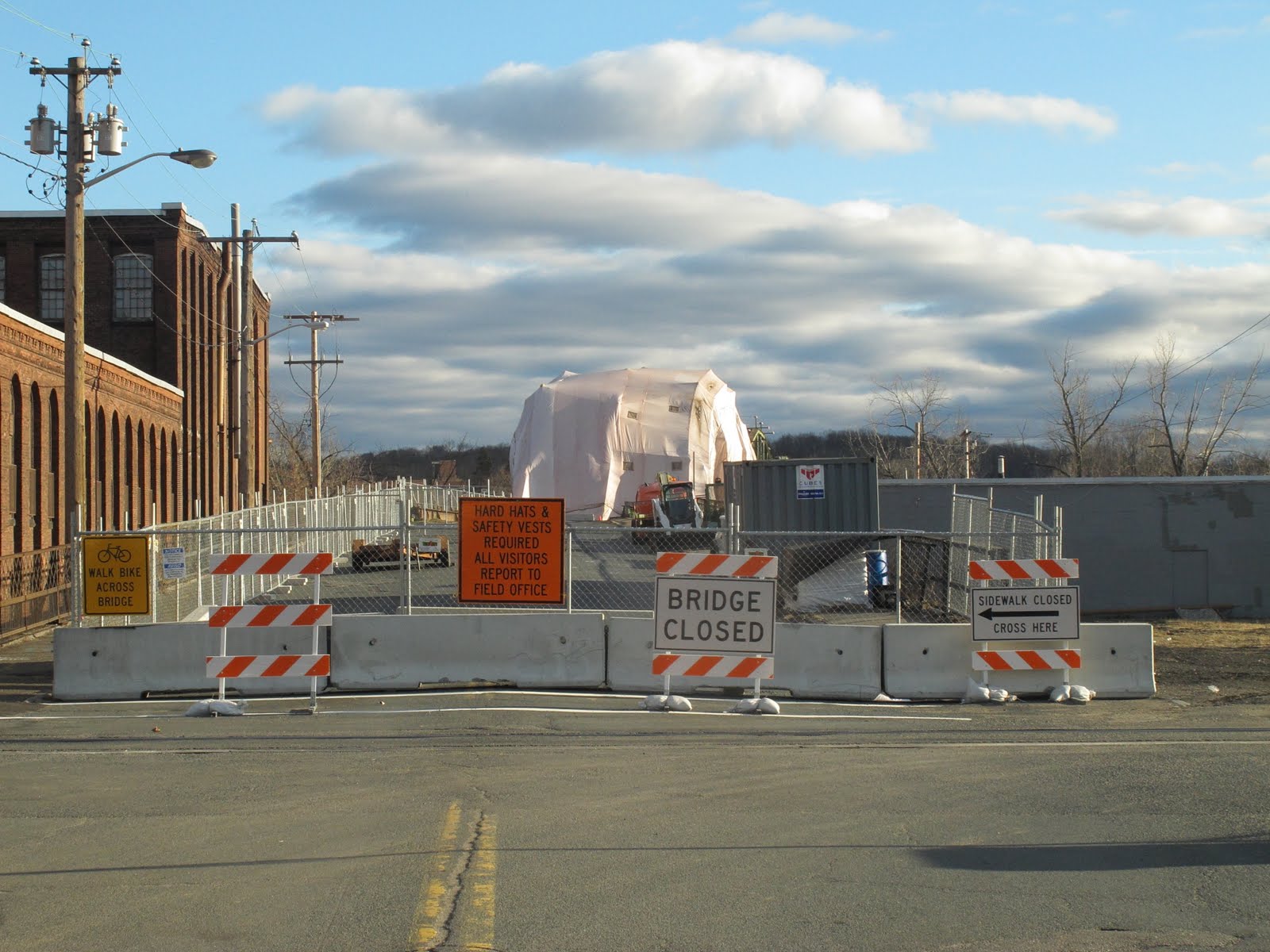
The Willimansett Bridge is a four span truss bridge over the Connecticut River. Built in 1891, this old bridge is currently closed to traffic while it undergoes an expensive renovation. Over 15,000 cars are said to have crossed this daily when it was open, which is frankly astonishing. Now drivers have to go a couple miles downriver to take Route 391 across.

The Route 391 bridge is boring, but it is definitely the best vantage from which to see the Willimansett Bridge -- but only at highway speeds from your car, as there is no pedestrian access on that bridge. There is, however, pedestrian access on the Willimansett.

It looks as if you could probably climb down the north bank on the Chicopee side of the bridge and get a better view, but by this time I was already quite a long way from my car and getting nervous about it, as I'd accidentally left my phone on the front seat.


Holyoke has a canal running alongside the Connecticut which is crossed by several other bridges. The Water Street bridge, above, crosses one outlet of the canal as it heads to a dam and into the river. You can see a bridge crossing the dam itself in the background.


This short, three span arch bridge takes Cabot Street over the canal and up to the Willimansett Bridge. With the canal crossed by all these low bridges, I'm not sure what the function of the canal IS. Maybe irrigation?


The Willimansett Bridge in the background, covered by tarp while workers work inside it. Pedestrian access is to the left.


On the Willimansett. I still had my camera with the bad lens at this point, and my phone with its excellent camera was (as mentioned above) back in the car, so I couldn't take pictures that looked toward the west (or the bridge), where the sun was shining, without having the image ruined by huge flaws. Gotta get that fixed, because the G12 is a really good camera and it cost me a lot of money. Even broken, it takes these fantastic pictures with incredible color.

Truss bridges aren't particularly rare around here, but every one is unique, all of them beautiful, and most of them were the lifeblood of their communities. I can only imagine how proud the people who lived in Holyoke were of their bridge when it was built 121 years ago.

Willimansett Bridge ca 1893

Sunday, February 12, 2012

Tomlinson Lift Bridge, New Haven, CT

Tomlinson Lift Bridge
As I feared, the Connecticut River Eagle Cruise was canceled today due to the weather -- high winds were whipping the river to a froth. We're rescheduled for next Saturday and are hoping for better, or at least quieter, weather. Probably still be cold, though. January may have forgotten the season, but February remembers.

The Tomlinson Lift bridge, and its parallel partner, the Pearl Harbor Memorial Bridge, cross the mouth of the Quinnipiac River as it empties into New Haven Harbor. The P.H.M. Bridge, AKA the Quinnipiac Bridge or simply the Q Bridge, is easily tall enough to let the tankers and container ships crawl a little further upriver, but the Tomlinson Bridge, which carries local traffic, needs a lift.

Taken from Long Wharf
I've seen a few lift bridges -- I saw a couple nice ones in Bridgeport last weekend -- but the Tomlinson is the nicest. Aluminum cladding gives the towers a classy feel, and the pale blue truss paint blend naturally with the harbor water and the sky.

It's a perfect complement to its setting and is a magnificent bridge for all its small size.

The Hardesty & Hanover civil engineering firm completely revamped the Tomlinson Lift Bridge about a decade ago; there's a complete report about the work (and some amazing aerial photos showing the bridge along with the "old" Q Bridge) on their website.

There's a floating platform where sightseers can look at the bridge or the ships in the harbor on the east side of the bridge. There's no decent place to park for it, though. The area immediately around the bridge is closed off while the Q Bridge is expanded. An oil pumping station (to the left in both pictures) closes off the west end of the bridge. Up the road a bit on the east side are some small businesses and residential areas, not fantastic places to park. I parked in a banquet hall parking lot about half a mile away.

It was worth it!

The second picture was taken from Long Wharf Park, which is another really great place to view the ships in the harbor, the lift bridge and the Q bridge. It's also a fantastic place for clam digging (but you probably need a license for that). The east point of the park has some utterly beautiful memorials to fallen soldiers. People on my social networks have seen this picture many times... and here it is again.

Veteran's Memorial in Long Wharf Park
Tanker delivering oil
Container ship unloading

Friday, February 10, 2012

Edgewood Ave Bridge, New Haven, CT


The weekend for my Connecticut River Cruise / Bald Eagle (photo) shoot / East Haddam Bridge Re-visit finally arrives and the climate remembers it's supposed to be winter. They've cancelled the morning cruises Saturday and Sunday, and the later cruises on those days are "watch this space!". I won't know if Sunday is a go until Sunday morning.

Anyway. Last weekend's third stop after Bridgeport and Stratford was friendly old New Haven, just three quarters of an hour south. New Haven provides a calm harbor for shipping where the Quinnipiac River flows into Long Island Sound. New Haven is also home to Yale University, which today's bridge is kinda near. Well, honestly, anywhere in New Haven is kinda close to Yale. Its tendrils reach throughout the city.


The Edgewood Bridge crosses the West River in the center of Edgewood Park (just head down Yale Boulevard; you'll find it; it's near the Yale Bowl). It's made of steel-reinforced concrete. Special care was taken with the molded balustrades and other ornamentation to make the Edgewood Bridge truly spectacular. With the ornate railings above, and the road/jogging path running through the arches below, this is a bridge truly meant to be seen and appreciated.


You can park along the street. Access to the path and river is via staircases at all four corners of the bridge. Edgewood Park is a really, really nice place, and I can just imagine how wonderful it will look in season. Come for the park, definitely, but go by the bridge while you're there.

Monday, February 6, 2012

The Bridges of Bridgeport: Congress Street Bridge, et al


With a city named "Bridgeport", how could a bridge hunter go wrong? It was the Congress Street Bridge that made the list of historical bridges -- you can see it blurrily in the background there -- but the city is known for its large number of bridges.

Well, the Congress Street Bridge is closed. The movable bit -- the bascule -- is removed, and the bridge is all blocked off.


Here's a picture of the other side of the Congress Street Bridge. It's a nice enough bridge. It was frozen in the upright position, and I was hoping to get a shot of that. But they were gone, and what's left is nothing worth a trip.


Turning to the other direction is a nice lift bridge. It carries the Amtrak tracks over the Pequonnock River.


There's another lift bridge around the bend in the river that carries pedestrian and auto traffic across the river, and finally, the biggest bridge of all...


The I-95 bridge over the river. It continues south along the coast to New York City, and east toward the mouths of the Housatonic, Quinnipiac, Connecticut and Mystic rivers -- each of which bear prettier bridges.

Saturday, February 4, 2012

Washington Bridge, Stratford-Milford, CT

Washington Bridge
I was thinking this weekend I wouldn't go bridge hunting, but come Thursday I was already sketching out plans to start photographing some of the many bridges in Fairfield County. Fairfield County is pretty much New York City's sixth borough, and as such is the perfect run-up to my Manhattan trip sometime this spring.

I started the morning heading down Route 15 to Bridgeport. Route 15 had a lot of amazing bridges crossing it, but I had no place to stop so they went unphotographed. Next time, I'll set up something so I can set my phone on the dash and it can automatically snap pictures and get these bridges uploaded.

Bridgeport was supposed to be a gimme; its name is Bridgeport! And there were bridges, and I'll eventually post them here, but they weren't something to get really excited about. I took my pictures and headed to Stratford to see the end of the Housatonic River as it empties into Long Island Sound. I was rewarded with an absolutely incredible bridge, the Washington Bridge, a six span open spandrel arch bridge with a two leaf bascule -- drawbridge -- in the middle.

I've been up in the north part of the state, where the Housatonic flows fast and free beneath the West Cornwall Covered Bridge and to a lot of the bridges that cross it along the way. Dammed three times, it is slow and wide here.

The bridge is easy to get to; take exit 44 off Route 95 and head straight along Ferry Boulevard to the shopping center at the end. There's a private marina there, and a small park with a public wharf that goes aways into the river. You can cross beneath the bridge and find wooden paths down to some public piers which give a great view of the bridge (such as the one that heads this post). The bridge has sidewalks crossing it on both sides; the south side gives grand views of the river delta, the north side looks down on the marina and over to the Route 95 river crossing and railroad bridge. The railroad bridge might be a swing bridge, but I think it might be a lift bridge. It was hard to tell from where I was, but the giant towers over it suggest to me that it is a lift bridge.

I-95 river crossing

Wednesday, February 1, 2012

Bridge of the Day: Burnside Bridge, East Hartford, CT

Burnside Bridge
"Bridge of the Day" is for bridges I find on my way to work, maybe with a little detour along the way. To be honest, though, I didn't even know this bridge existed. There's no way I would have found this on my own. I was shocked to read about it on the CT Historic Bridge site. It's on a side road, the stonework isn't visible from the road, the only way you'd see it is if you decided to take this moment to look at the Hockanum River, but wait -- you wanted to climb down the bank, over the suspiciously bamboo-like reeds, and see it from water level. And then -- there's this bridge!


I guess you could see it from the houses over behind it, in the winter when the foliage wouldn't block it. And the people in the factory across the street probably know all about it.


CT Historic Bridges says the Burnside Bridge was "... Connecticut's first example of a "City Beautiful" bridge. Its graceful lines and granite-ashlar exterior show that it was intended to be aesthetically pleasing as well as functional."


Sorry for the blown out sky. Overcast morning. The only way to get any detail in the sky was HDR, and I wasn't set up for that.


The bike path from Manchester to East Hartford follows the Hockanum River for most of the way, so I have a couple other pictures to share.


This tunnel runs beneath the complicated 84/384 interchange. Left goes to Manchester Community College, and right goes to Hartford. Back the way I came is Wickham Park -- the subject of many photos -- and home. I actually took this picture yesterday. I wanted to get the Burnside Bridge photographed yesterday, but lack of research had me going left instead of right. Getting lost takes longer on a bicycle, but once I realized my mistake, it was far too late to head back the other way. I had to go straight to work.


This is why there's some sky showing in these two pictures while the one of the bridge I came to shoot is overcast. Plus these were phone pictures, and my phone has built in HDR. It's not perfect, but it works well enough.


This bridge is part of the same interchange system; the one above was just a little ahead of this shot. The Hockanum River runs placidly through it on its way to a dam that forms a small lake just before the Burnside Bridge. Once released from the dam, the river flows rapidly to its end in the Connecticut River.